Leica 3-D DISTO The world's first
Leica 3-D DISTO, the world's first for spatial measurement -technology developed by the market leader Leica!
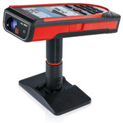
Leica has gone even further and oriented itself to the needs on site. With the 3-D-Disto, everything can be measured from one point and digitally captured at the same time. The laser is motorized and controlled from a tablet, and its sensors correctly record all rotational and panning movements.
The 3D Disto from Leica Geosystems is a unique device for capturing and reproducing precise 3D measurements. The speed and precision of the 3D Disto give unprecedented efficiency to the following applications:
- CAD template creation: CNC is only as good as your files are. A 3D Disto is the bridge between reality and CAD. When you do dimensional work and are confident that your original measurement data is correct, you can machine even the most expensive materials without worry.
- 3D Visualization and Navigation: The updated Leica 3D Disto software for smart devices running Windows® now displays results in 3D. 3D navigation makes it even easier to check measured points.
- As-built measurements: Avoid surprises that arise later by knowing exactly what you are starting with. The 3D Disto ensures that 3D coordinates are recorded correctly and with a precision that every design needs. If your job includes handling expensive materials that are difficult to cut, transport, or process, then correct on-site measurements play a critical role.
- Building Information Modeling (BIM): Get DXF data directly to your Windows tablet and use 3D Disto to arrange anchor points, transfer elevations, or check critical job sites.
No matter what you use the 3D Disto for, the most important thing is precision. Form fits function, which is why the 3D Disto works like a cross between a robotic surveyor and a hand-held DISTO™.
Like a surveying robot, the 3D Disto unit's horizontal and vertical axes of rotation are motorized -- manually bring the laser dot as close as possible to the correct starting point, use the video feed to help you do this by tapping the target on either a remote control tablet or a Windows tablet, and then watch the 3D Disto rotate and pan until the laser dot is in the crosshairs.
All credit to the laser. However, to measure up to 1 mm accuracy @ 10 m, the 3D Disto measures both horizontal and vertical angle as well as slant distance with angle measurement sensors that our total stations also use. This is a technology that Leica Geosystems has been advancing for over 90 years.
Tablet and tripod are not included.
Recommended Windows tablets: Microsoft Surface Pro 3- i5, 12", Windows 10
Recommended tripod: CTP106-1 Lightweight aluminum tripod
Flipbook with control unit(English)
If you are interested, please contact us. You can also find more information on the Leica manufacturer's site https://lasers.leica-geosystems.com/eu/de/buy-3d-disto.